

The Field Regina Northrop Neighborhood:
Historical Highlights
By Richard L. Kronick
Mni Sota Makoce: The Dakota homeland
The area that became FRN was, from about the middle of the 18th century, part of the homeland of Dakota people. The name “Dakota” translates as “allies” or “the league” and implies strength through intra-tribal unity.(1) A 1720 report by a Frenchman stated that the Dakota believed “the first [man] and woman of their tribe came out of the earth, which brought them forth on the prairie below St. Anthony Falls.” More specifically, many Dakota believed, and still believe today, that “the mouth of the Minnesota River [at its confluence with the Mississippi] is precisely over the center of the earth, called Bdote, and that [the Dakota] occupy the gate that opens into the western world.”(2)
Early non-native occupation
In 1805, Captain Zebulon Pike (after whom Pike’s Peak was later named), on orders from the US government, traveled up the Mississippi River from St. Louis and met with a few Mdewakanton Dakota people at Bdote. Pike negotiated a treaty with those people that traded a parcel of land to the US for cash and other considerations. Though some Dakota people, historians, and legal experts question the validity of the treaty, that parcel was the first land acquired by the United States in what eventually became Minnesota. The 100,000-acre parcel, which contains the Field Regina Northrop (FRN) Neighborhood, was roughly triangular. It was bounded on the west by Lakes Harriet and Bde Maka Ska (previously Lake Calhoun), St. Anthony Falls at its northern corner, and the Minnesota River at its southeastern corner. Beginning in 1819, Fort Snelling was built on the high bluff where the two rivers meet because it was a strategic point from which the US Army could oversee the fur trade and monitor the actions of rival Dakota and Ojibwe groups.

Figure 1: 1835 map of Fort Snelling Military Reserve drawn by Major Lawrence Talliaferro.

Figure 2: Detail of map in Figure 1
A roughly drawn 1835 map of the parcel (Figures 1 & 2) shows “Brush Wood Hills” immediately north of Brown’s Creek (now Minnehaha Creek) in the area that includes FRN. The creek was named for Joseph Renshaw Brown, a soldier in the first contingent that built Fort Snelling. After mustering out of the army, Brown became the first person to stake a property claim on the creek.(3) Also shown on the map are Lake Amelia and Rice Lake. Lake Amelia was named in 1819 for the daughter of Captain George Gooding, an officer at Fort Snelling. In 1910, the Minneapolis Park and Recreation Board renamed Lake Amelia as Lake Nokomis and Rice Lake as Lake Hiawatha. Brown’s Creek (or Brown’s River) had been renamed as Minnehaha Creek in the late 19th century. These new names were inspired by characters in Henry Wadsworth Longfellow’s famous 1855 epic poem, “The Song of Hiawatha.”
Two cemeteries
Before the turn of the 20th century, two cemeteries were established in and near the area that became FRN. Immediately to the north of FRN and bounded by East 42nd Street and 3rd and 4th Avenues South is the Temple Israel Memorial Park. Originally named Montefiore Cemetery after a British writer and Zionist, the cemetery was established in 1876 (before establishment of Temple Israel Synagogue, which now owns it) when its 4.5 acres were well beyond Minneapolis’s southern border, 24th St. The cemetery’s gate house/chapel, built in 1894, was designed in the Richardsonian Romanesque style by architect Septimus J. Bowler. This style was created by and is named for Henry Hobson Richardson, a Cambridge, Massachusetts, architect. Patterned after European cathedrals and monasteries built during the early Middle Ages, the style is characterized by rough-cut stone masonry and was said to symbolize the tough-yet-refined character of American pioneers.
St. Mary’s Cemetery, between East 44th and 46th Streets, and Chicago and 14th Avenues South (address: 4403 Chicago Avenue), is completely within the borders of FRN. It has undergone two name changes. At its founding in 1868, it was simply called the West Side Catholic Cemetery to distinguish it from the St. Anthony [Catholic] Cemetery on the east side of the Mississippi River. By the 1880s, it was renamed the Immaculate Conception Cemetery to tie it to a church of the same name that had been established in 1872 in downtown Minneapolis. The cemetery received its current name in 1890. In 1904, the Chicago Avenue streetcar line was extended from its 38th St. terminal to 48th Street expressly to service the cemetery and St. Joseph’s Home for Children; the cemetery has been administered by The Catholic Cemeteries since that entity was created in the 1920s.
St. Joseph’s Home for Children
St. Joseph’s Home for Children was founded in 1878 as the Minneapolis Catholic Orphan Asylum and was staffed by nuns of the Order of St. Joseph’s of Carondelet. Its first location was at the east end of the Hennepin Avenue Bridge over the Mississippi River in a building that had been the Winslow House Hotel but was reconfigured as a hospital. In 1879, the orphanage moved to a building across the river in what is now the warehouse district. At that time, the Twin Cities Catholic Archdiocese placed all orphaned boys under its care in this Minneapolis location while orphaned girls were housed in St. Paul.

Figure 3: Original buildings of the Minneapolis Catholic Orphanage as shown in the Minneapolis Star Tribune, 11/7/1915. The main building, at left in this view from Chicago Avenue, and the chapel next to it were demolished and replaced by the current administration building in 1915. Most of the building shown on the right, including the brick chimney, remain as a component of today’s “St. Joe’s.”
In 1886, the orphanage moved to its current location (within FRN) between 10th and 13th Avenues South and between East 46th and 47th Streets. The land was donated by Hennepin County commissioner M. W. Nash. The orphanage was purposely located across 46th Street from St. Mary’s Cemetery; the cemetery contains graves of nuns and boys from the orphanage. Bishop John Ireland of the Twin Cities Catholic Archdiocese spoke at the groundbreaking of “a fine brick structure with stone foundations and all the modern improvements” (in Figure 3) that was constructed for about $30,000. In the 1890s, the top floor of the building was condemned as unsafe and it was later demolished. In 1907, St. Francis Xavier Chapel (at center in Figure 3) was built. In 1915, the dark brick building that still faces 47th Street today was built.(4)
The grounds of St. Joe’s originally encompassed 40 acres, later grew to 80 acres, and stretched from 46th Street all the way to Minnehaha Creek. Around the turn of the 20th century, the location was described as a half day’s journey from downtown Minneapolis, “far from the ills of city life.”(5) In those days, the boys and the nuns tended a large garden and milked cows on the grounds. However, to raise funds in 1927, all but ten of the original 80 acres were sold to private developers for home sites – where many of us FRNers now live. Most of the building in Figure 3 still stands, including its octagonal smokestack. Today, St. Joe’s provides programs for “children in crisis, children with mental health issues, and homeless teens.” It is “often the first temporary placement for children who are the subject of a child placement petition.”(6)
McRae Park
In the 1940s, the Minneapolis Park and Recreation Board bought eight acres of the land for $24,000 that became McRae Park. Half of the land was bought from the state of Minnesota and was tax-delinquent land that had been foreclosed on during the Great Depression. The other half was acquired by condemnation.(7)
Six 19th century mill sites on Minnehaha Creek
Before 1897 when a dam was built at the mouth of Minnehaha Creek on the east end of Lake Minnetonka, the creek was powerful enough to run six flour mills.(8) One of the earliest of these was constructed in 1847 where Lyndale Avenue crosses the creek, just west of the area that became FRN. That mill was owned by Franklin Steele, a prominent land speculator and businessman (Steele County in southern Minnesota is named for him). The mill was operated by Ard Godfrey, whose home, now preserved and placed in Chute Square at the intersection of Central and University Avenues in Northeast Minneapolis, is the oldest surviving house in Minneapolis.
The roaring ’20s: FRN comes of age
The period just after World War I saw growth and expansion in every aspect of the American economy as demand that had been pent up during the war years was suddenly released. The resulting housing boom was the essential force that shaped FRN, which was then at Minneapolis’ outer edge and prime for development. When Lake Amelia (Nokomis) was acquired in 1907 by the Minneapolis Park and Recreation Board, it was very shallow — about five feet at its deepest place — and was swampy in many places.(9) Beginning in 1914, under the direction of Park and Recreation Board Superintendent Theodore Wirth, the lake was dredged (Fig. 4).(10) By 1924, the swampy land around Lake Nokomis had been filled and landscaped to create the basic shape of the lake and park we see today. Ironically, in recent years, swampy areas were recreated at the southwest end of the lake after scientists showed that wetlands act as filters to keep unwanted chemicals out of lakes.
![Figure 4: 1920s — dredging Lake Nokomis. [Courtesy Hennepin County Library Minneapolis Collection]](https://images.squarespace-cdn.com/content/v1/5f8071afbb56c84e2e0e95ac/1603070705864-BTHCNX6YH0E13VJUH2WA/Kronick_4.jpeg)
Figure 4: 1920s — dredging Lake Nokomis. [Courtesy Hennepin County Library Minneapolis Collection]
The development of Lake Nokomis and the concurrent construction of Minnehaha Parkway dramatically increased the neighborhood's attractiveness. FRN’s residential character was largely determined by a 1924 zoning ordinance that restricted development almost entirely to single-family housing. A 1965 report of the Nokomis Community Group proclaimed that the Nokomis area contained the “largest stock of single-family homes of any neighborhood in the city.” As the neighborhood grew, transit came out to meet it; in 1928, the Chicago Avenue streetcar line was extended across Minnehaha Creek to 54th Street, then the city limit.
From 1920 to 1940, about 7,700 housing units were built in the Lake Nokomis area. Between 1940 and 1950, about 3,000 more units were added and development in the area was largely complete. The 1990 census found that 74% of housing units in the Field area had been built before 1940.
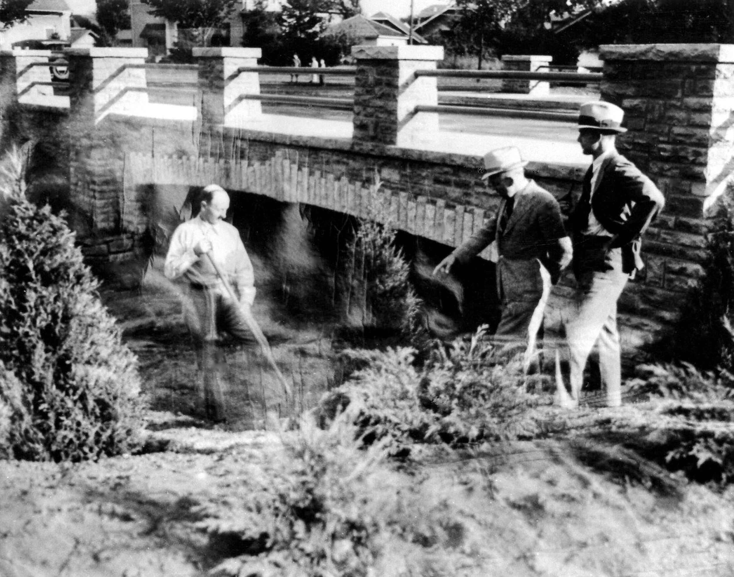
Figure 5: On Sept. 18, 1936, Minneapolis City Engineer Eric Gorgensen (right) and WPA Area Engineer M.B. Lagaard look on as worker R.D. Clint turns the last shovel of earth on the new bridge over Minnehaha Creek at 4th Ave. So. [Courtesy Hennepin County Library Minneapolis Collection]
In interviews, two longtime residents reminisced about the unbuilt areas around FRN. Florence Schuehle remembered that, during the 1920s, much of the land was still owned by farmers and that chickens, horses, and cows were plentiful. Frank Streed remembered that his favorite childhood haunts during the 1930s were a gravel pit at 43rd and 4th Avenue and the “Portland Woods” on the east side of Pearl Lake; the lake was later filled to make Pearl Park.(11)
Commercial development
By the 1920s there were two burgeoning commercial districts in FRN — one at 48th and Chicago and the other at 48th and Fourth Avenue. Both were classic examples of the “streetcar corner,” a phenomenon that grew up at regular nodes along streetcar lines. Each of these corners had three grocery stores plus bakeries, pharmacies, and other purveyors of basic daily needs. When the Chicago Avenue streetcar line was extended beyond Minnehaha Creek, 48th and Chicago began to surpass the 48th and Fourth Avenue district as a hub. By 1967, the decline of 48th and Fourth was assured when Interstate Highway 35W cut the area off from the western half of its customer base.
In fact, Mary Katherine Johnson, in her monograph, “The Development and Life Cycle of 48th and Chicago Avenue: A South Minneapolis Neighborhood Commercial District,” states that the building of 35W was by far the most influential transportation event in the history of the neighborhood.(12) It is not hard to see why. The freeway put large commercial districts, including downtown Minneapolis and Southdale, just minutes away from FRN residents. This wrought a fundamental change at 48th and Chicago. Gradually, stores selling groceries, clothing, and other basic needs gave way to restaurants and establishments offering specialty goods and services.
In 1975, the South Chicago Avenue Business Alliance (SCABA) was formed to guide the future of 48th and Chicago. The organization has been instrumental in attracting both public and private development funds to the corner and exerts peer pressure on the area’s businesses to maintain consistently high levels of service.
Field School: a touchstone in neighborhood history
No institution has played a more central role in FRN’s history than its first school, which was named for Eugene Field, author of “Wynken, Blynken, and Nod” and other popular children’s poems. The school, opened in 1886 as a one-room building at 48th and Portland, was designed by Minneapolis architect Harry Wild Jones. Some of Jones’ better-known works in Minneapolis are the Butler Brothers Warehouse, now called Butler Square, the Washburn Water Tower, and the ornate Memorial Chapel at Lakewood Cemetery. Jones’ own house still stands just west of FRN at 5101 Nicollet.
Field School became part of Minneapolis Public Schools in 1896 and, in 1898, was serving 19 students. By 1919, when there were 90 homes in Field’s service area, 122 students attended the school. The original building was closed in 1921 when the school moved to its current location at 46th and 4th Avenue South. The original building then became Portland Avenue Christian Church.(13)
In 1971, Field School became a focal point in a citywide effort to achieve racial balance in the public schools. In that year, Field was “paired” with Hale School. Prior to 1971, Hale, just a few blocks south of FRN, had fewer than 3% students of color, while Field had over 70% students of color, mostly African American. These statistics compare strikingly with the fact that Minneapolis’ overall population at the time was about 10% African American.
In response to this and many other instances of racial imbalance, the Minnesota Supreme Court mandated that school busing would be used to achieve racial integration. Through the organizing efforts of many FRN residents — and over the protests of many others — Field and Hale were successfully paired. They became a single K-6 (currently K-8) program, serving students from the neighborhoods surrounding both schools. The pairing achieved the goal of the court order: a maximum of 30% students of color in any school. Field-Hale was one of the first successful instances of the city’s overall desegregation program and became nationally known as a successful experiment in the racial integration of public schools.(14)
Richard L. Kronick is a freelance writer and architectural historian. He and his family have lived in FRN for more than 40 years.
REFERENCES:
1 Gary Clayton Anderson: Little Crow: Spokesman for the Sioux (St. Paul: Minnesota Historical Society Press, 1986), p. 10.
2 Microfilm of the 1720 report is at the Minnesota Historical Society. The second quotation is from the missionary Steven R. Riggs: Dakota Grammar and Lexicon (Smithsonian Institution, 1852). Both are quoted by Gwen Westerman and Bruce White in Mni Sota Makoce: The Land of the Dakota (St. Paul: Minnesota Historical Society, 2012), p. 19.
3 Some historians have suggested that Brown’s Creek (also called Brown’s River at times) was named for Major General Jacob Brown, the commander-in-chief of the US army during the time Fort Snelling was built. However, it appears that local people thought of the name in association with Joseph Brown who set up shop on his land claim at the mouth of the creek where he sold alcoholic beverages and thus became a thorn in the side of local authorities.
4 “The Orphan’s Fair,” Minneapolis Star Tribune, September 1, 1889, p. 5; and “Institution Building on Chicago Avenue Built on Borrowed Money,” Minneapolis Star Tribune, November 7, 1915, p. 16.
5 William Mitchell Law Review, volume 32:3 (2006), pp. 1031 and 1032.
6 William Mitchell Law Review, op. cit., p. 1033.
7 David C. Smith: City of Parks: The Story of Minneapolis Parks (Minneapolis: The Foundation for Minneapolis Parks, 2008), p. 155.
8 Foster W. Dunwiddie: “The Six Flouring Mills on Minnehaha Creek,” Minnesota History, Spring, 1975.
9 Wikipedia: “Lake Nokomis,” accessed 1/1/2019.
10 David C. Smith: City of Parks: The Story of Minneapolis Parks (Minneapolis: The Foundation for Minneapolis Parks, 2008), p. 110.
11 Manuscripts collected as part of an oral history project by FRN Neighborhood Group: interview with Florence Schuehle: March 26, 1995; interview with Frank Streed: April 24, 1995.
12 Mary Katherine Johnson: “The Development and Life Cycle of 48th and Chicago Avenue: A South Minneapolis Neighborhood Commercial District,” undated manuscript.
13 “Looking Back at Field School History,” unpublished manuscript, 1966.
14 Karla Petit, “Desegregation by Pairing: A History of the Pairing of Hale and Field Elementary Schools,” unpublished manuscript, May 1995.